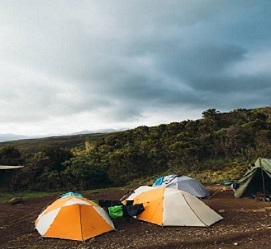
The 7 days Machame route climbing kilimanjaro, also known as the "Whiskey" route, is the most popular route on Kilimanjaro. Machame’s draw is in its scenic beauty. However, the trail is considered difficult, steep and challenging, particularly due to its shorter itinerary. Therefore, this route is better suited for more adventurous folks or those with some high altitude, hiking or backpacking experience.
The route approaches Mount Kilimanjaro from the south, this route starts with a short drive from Moshi to Machame Gate. The path leads hikers through the rain forest to Shira Plateau. Here, many of Kilimanjaro’s routes converge. Then the route turns east and traverses’ underneath Kilimanjaro's Southern Ice Field on a path known as the Southern Circuit before summiting from Barafu. Descent is made via the Mweka route.
Elevation (ft): 1,800 m to 2835 m
Distance: 11 km
Hiking Time: 5-6 hours
Habitat: Montane Forest/ Rain Forest.
Full Board at Machame Camp
The climb starts from Machame gate (1830m), we walk through the lush lower slopes of Mt. Kilimanjaro. Slowly gaining altitude while enjoying the diverse flora and fauna of the rain forest, you will arrive to the first Machame Camp, situated at 3000m above sea level If is a clear day, we may get our first closer look at the glaciated dome of Kibo if the evening clouds permit.
Elevation (ft): 2835 m to 3,750 m
Distance: 5 km
Walking Time: 5-6 hours
Habitat: Moorland
Full Board Shira Cave Camp.
A shorter day climbing up a steep ridge to reach a small semicircular cliff known as Picnic site, and continue up a gentler ascent through the lower alpine moorland, which is known for beautiful wild alpine flowers. The most spectacular views of Kibo peak can be seen from Shira Camp.
Elevation (ft): Shira Cave camp 3,750 m to Baraco Camp 3,900 m
Distance: 10 km
Walking Time: 5 to 6 hours
Habitat: Moorland
Accommodation: Barranco Camp
Today we walk on a gentle ascent and panoramic views. We traverse the southwest side of Kilimanjaro, passing underneath the Lava Tower and the final section of the Western Breach and after hot lunch the bottom of the Lava Tower (4,600 m.) we descend to the bottom of the Great Barranco valley (3,950 m.).
Elevation (ft): Barranco Camp 3,900 m to Karanga Camp 3995 m
Distance: 6 km
Hiking Time: 3.5 to 4 hours
Habitat: Moorland
Accommodations: Karanga Camp.
A steep climb up the eastern wall leads us just below the Heim Glacier, where we may have some spectacular views of Kilimanjaro. We then take a steep exit up the Great Barranco Wall, which divides us from the southeastern slopes of Kibo, the trail continues down into the alpine desert of the Karanga Valley, finally we have a steep climb up to Karanga Camp.
Elevation (ft): Karanga camp 3995 m to Barafu Camp 4,673 m
Distance: 4 km
Hiking Time: 3-4 hours
Habitat: Alpine Desert
Accommodations: Barafu Hut Camp.
A steep climb out of Karanga, and an easy path on compacted scree with wide views through this empty and dry landscape up to Barafu Camp. The two peaks Kibo and Mawenzi can been seen from Barafu Camp. After a hot lunch at the Camp, the remainder of the day is spent resting as we prepare for the final ascent before an early night summit walk.
Elevation (ft): Barafu Camp 4,673 m to Uhuru peak 5,895 m {Via Stella Point 5756m}
Distance: 4.3 km ascent to Stella Point
Distance: 5 km Barafu to Uhuru Peak Ascent.
Hiking Time: 6-7hours ascent / 7-8 hours descent
Habitat: Alpine Desert
Accommodations: Mweka Camp.
Wake up before midnight in the cover of darkness. We begin a steep climb over loose volcanic scree has some well-graded zig-zags and a slow but steady pace will take us to rim of the main crater, Stella Point, at 5,735m. We will rest there for few minutes to enjoy the sunrise over Mawenzi. Those who are still feeling good can continue slowly to make the two hours round trip from here along the crater rim to main peak (5,895 m), which is the highest point in Africa. After a few minutes to appreciate your accomplishment, we descend to Barafu is amazingly fast, and we stop at Barafu Camp for some refreshment, we continue to descend to reach Mweka Camp.
Elevation (ft): Mweka camp3,100 m to Mweka Gate 1,640 m
Distance: 10 km
Hiking Time: 4 -5 hours
Habitat: Montane Forest
Half Board
A gentle walk takes us down through the rainforest to Mweka gate successful climbers will receive their summit certificates. After lunch we drive back to Moshi to your hotel.