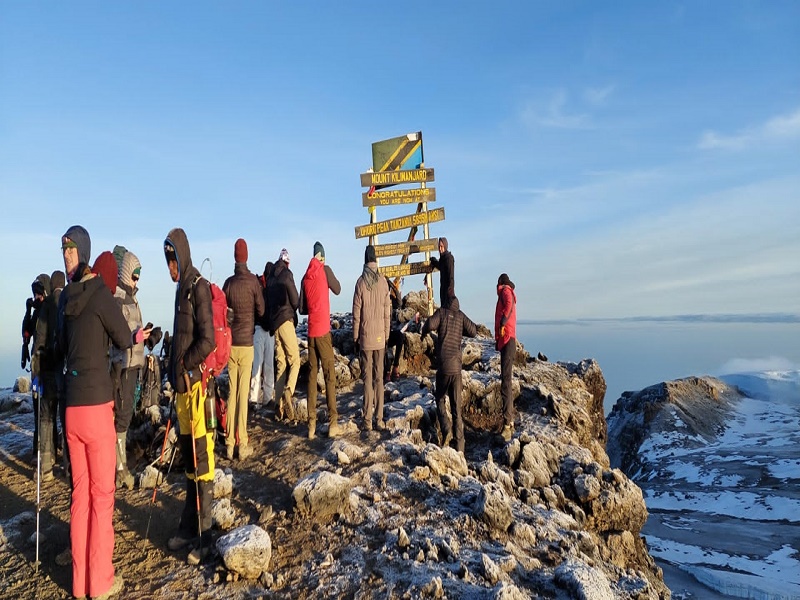
The ultimate guide to the best 7-Day Lemosho Route is the ideal choice for those seeking a scenic and rewarding way to summit Mount Kilimanjaro , Africa’s highest peak. Starting from the less-traveled western side of the mountain, this route offers climbers a breathtaking journey through a variety of ecosystems, from lush rainforests to alpine meadows and high-altitude deserts. Known for its stunning vistas, the Lemosho Route is designed to provide optimal acclimatization, which increases your chances of reaching the summit. Over the course of seven days, climbers will experience gradual ascents, allowing their bodies to adjust to the changing altitude, while being surrounded by awe-inspiring landscapes. The route’s well-planned itinerary ensures a high success rate for summiting Uhuru Peak. Accompanied by expert guides and a supportive team, the Lemosho Route is perfect for climbers of all levels, offering an unforgettable adventure in one of the world’s most spectacular natural environments.
Plan your Best 7-Day Lemosho route - Climb Kilimanjaro now!
Book your The Ultimate 7-Day Lemosho Route Guide – Climb Kilimanjaro's Most Scenic and Rewarding Trail at an affordable price. We will reply to you shortly on WhatsApp and email.
The most affordable price for the 7-Day Lemosho Route Guide – Climb Kilimanjaro's Most Scenic and Rewarding Trail ranges from USD 1450 to USD 3000 per person, depending on various factors such as the time of year, level of accommodation, and the inclusion of additional services like guides, porters, meals, and park fees. This range ensures that climbers of different budgets can experience one of the most breathtaking and rewarding trekking routes on Mount Kilimanjaro. The Lemosho Route is known for its stunning views, gradual ascent, and optimal acclimatization, making it a popular choice for climbers aiming to reach the summit with a high success rate. Whether you're seeking a more affordable, basic experience or prefer a luxurious journey with added comforts, this price range accommodates both options, offering exceptional value for an unforgettable adventure on Africa's tallest peak.
Discover our top-best 7-Day Lemosho Route – Climb Kilimanjaro Tour package offers an unforgettable adventure to the summit of Africa’s highest peak. Renowned for its scenic beauty and gradual ascent, this route takes climbers through diverse ecosystems, including lush rainforests, alpine meadows, and barren deserts, providing stunning vistas along the way. The package includes expert guides, porters, and full support to ensure a safe and successful trek. With a focus on optimal acclimatization, the Lemosho route increases your chances of summiting Uhuru Peak, offering one of the highest success rates among Kilimanjaro routes. Ideal for climbers of all levels, the 7-day itinerary allows for a balance of challenge and scenic enjoyment, making it perfect for those seeking a rewarding and scenic climb. From start to finish, you’ll experience the thrill of reaching the summit, backed by a well-organized team and a route that offers both adventure and incredible natural beauty.
The best 7-Day Lemosho Route is a highly recommended group tour for climbers seeking to conquer Mount Kilimanjaro, Africa's highest peak at 5,895 meters. Departure dates for this scenic and rewarding trek are available year-round, with the best times being during the dry seasons, from early January to mid-March and June, July, August, September to October, offering clear skies and favorable weather conditions. Starting on Kilimanjaro’s western side, the route covers approximately 70 kilometers and takes climbers through stunning landscapes, including dense rainforests, moorlands, and high-altitude alpine deserts. Group tours enhance the trekking experience with shared camaraderie, cost-sharing benefits, and professional support from experienced guides and porters. With a success rate of over 90%, this route includes ample acclimatization opportunities, increasing the likelihood of reaching Uhuru Peak while enjoying breathtaking views.
The 7-Day Lemosho Route offers a meticulously planned itinerary that provides a scenic and rewarding journey for climbers aspiring to conquer Mount Kilimanjaro. Day 1: Starting from Arusha | Moshi to Londorossi Gate, the trek begins through lush rainforests to Mti Mkubwa Camp, followed by a gradual ascent across the stunning Shira Plateau to Shira Camps 1 and 2. The route includes crucial acclimatization stops at Lava Tower and Barranco Camp, enhancing altitude adjustment. Key highlights include the exhilarating climb of the Barranco Wall and the scenic trek through Karanga Valley to Barafu Camp, the base for the summit push. The final ascent starts at midnight, culminating at Uhuru Peak at sunrise, offering an unforgettable moment of triumph. The descent through montane forests to Mweka Gate completes this balanced itinerary, blending adventure, safety, and breathtaking landscapes, making it one of the most rewarding routes to summit Kilimanjaro.
Day 1: Arusha | Moshi to Londorossi Gate to Forest Camp
Elevation (ft): 7,800ft to 9,500ft
Distance: 6 km
Hiking Time:3-4 hours
Habitat: Rain Forest
We depart Arusha/Moshi for Londorossi Gate, which takes about 4 hours, where you will complete entry formalities. Then drive to the Lemosho trailhead (another hour to reach the trailhead). Upon arrival at trailhead, we eat lunch, and then commence through undisturbed forest which winds to the first camp site.
Elevation (ft): 11,500ft to 13,800 ft
Distance: 14 km
Hiking Time: 5-7 hours
Habitat: Moorland
We explore the Shira plateau for a full day. It is a gentle walk east toward Kibo’s glaciered peak, across the plateau which leads to Shira 2 camp on moorland meadows by a stream. Then we continue to Moir Hut, a little used site on the base of Lent Hills. A variety of walks are available on Lent Hills making this an excellent acclimatization opportunity. Shira is one of the highest plateaus on earth.
Elevation (ft):13,800ft to 13,000ft
Distance: 7 km
Hiking Time: 4-6 hours
Habitat:Semi Desert
From the Shira Plateau, we continue to the east up a ridge, passing the junction towards the peak of Kibo. As we continue, our direction changes to the South East towards the Lava Tower, called the “Shark’s Tooth.” Shortly after the tower, we come to the second junction which brings us up to the Arrow Glacier at an altitude of 16,000ft. We now continue down to the Barranco Hut at an altitude of 13,000ft. Here we rest, enjoy dinner, and overnight. Although you end the day at the same elevation as when you started, this day is very important for acclimatization and will help your body prepare for summit day.
Elevation (ft): 13,000ft to 15,000ft
Distance: 9km
Hiking Time: 8-10 hours
Habitat: Alpine Desert
After breakfast, we leave Barranco and continue on a steep ridge passing the Barranco Wall, to the Karanga Valley campsite. Then, we leave Karanga and hit the junction which connects with the Mweka Trail. We continue up to the Barafu Hut. At this point, you have completed the South Circuit, which offers views of the summit from many different angles. Here we make camp, rest, enjoy dinner, and prepare for the summit day. The two peaks of Mawenzi and Kibo are to be seen from this position.
Elevation (ft): 15,300ft to 19,345ft (and down to 10,000ft)
Distance: 5 km ascent / 12 km descent
Hiking Time: 7-8 hours ascent / 4-6 hours descent
Habitat: Arctic
Very early in the morning (midnight to 2am), we continue our way to the summit between the Rebmann and Ratzel glaciers. You head in a northwesterly direction and ascend through heavy scree towards Stella Point on the crater rim. This is the most mentally and physically challenging portion of the trek.
At Stella Point (18,600 ft), you will stop for a short rest and will be rewarded with the most magnificent sunrise you are ever likely to see (weather permitting). From Stella Point, you may encounter snow all the way on your 1-hour ascent to the summit. At Uhuru Peak, you have reached the highest point on Mount Kilimanjaro and the continent of Africa. Faster hikers will see the sunrise from the summit.
From the summit, we now make our descent continuing straight down to the Mweka Hut camp site, stopping at Barafu for lunch. You will want gaiters and trekking poles for the loose gravel going down. Mweka Camp is situated in the upper forest and mist or rain can be expected in the late afternoon. Later in the evening, we enjoy our last dinner on the mountain and a well-earned sleep.
Elevation (ft):
10,000ft to 5,400ftDistance:
10 kmHiking Time:
3-4 hoursSign up here to receive interesting updates
© TANZANIA NATURAL TOURS. All rights reserved.
